The Pamir - "the Roof of the World"
- is a large mountain system extending over the territory of Tadzhikistan
and Kirgistan republics. It has a form of almost quadrangular with
about 250 km of each side - tens of thousands of square kilometers
wilh dizzying peaks, snow-capped spires and towers, ice rivers constantly
rent by crevasses, and hanging glaciers. It is a veritable ocean
of white and blue mountains, whichever way you turn. The "roof
of the world" - this is what the Persians called the Pamirs;
and although the highest peaks in the world are in the Himalayas,
the Pamirs are slill the main orographic crux in Asia from which
the highest ranges in the world radiate: the Hindu Kush to the northwest,
the Tien Shan system to lhe northeast, the Karakorum and Himalaya
ranges to the southeast.
The Pamirs mark the southern boundary of Central Asia, lhe most
fascinating region in the Eurasian continent and the least developed
one from a touristic point of view. Separated from Russia by the
boundless Kazakhstan steppe and surrounded by deserts, Central Asia
was for centuries the crossroads for the trade routes between East
and West. it was here that already in the Ind century B.C. the nomad
populations traced the route that would later be called the Silk
Road. Here the legendary Genghis Khan led his Mongol troops in his
devastating invasions of parts of Europe; here reigned his successor
Tamerlane, so famous for his cruelty as well as for the great works
of art created under his rule, such as the monuments in Samarkand,
the capital of his empire. The Russian tsars conquered these regions
only in the early 1800s, but they never succeeded in influencing
the local culture to any extent. Then came the Soviet regime, which
attempted to "Russify" most of the republics of Central
Asia-Uzbekistan, Kyrgyzstan, Tadzhikstan, Kazakhstan, and Turkmenistan.
Despite this, much has remained of the peculiar character of each
county and today the cultures, religions and traditions of the various
peoples of Central Asia are passing through a phase of rebirth.
The most famous testament of the rich history of this part of Asia
are Samarkand, with its magical light blue domes; the enchanted
fortified oasis of Bukhara, where Marco Polo stayed; and Khiva,
the historic heart of which is a veritable open-air museum that
is still very much alive and all the more precious since most of
the historic towns in this vast region have been destroyed. Then
there are the cities of the Fergana valley still rich in cultural
tradition: Margelan, the ancient city lost in time with its streets
populated by Uzbeks with their typical costumes, old tea houses,
open markets with multicoloured fruit; Kokand, with its great Muslim
tradition and the Khan's well preserved, immense palace; the intriguing
Arab city of Osh with its traditional marketplace brimming wilh
perfumed pyramids of fruit and vegetables, dried fruit stalls, pitchers
of honey and fresh cheese, piles of tasty "lavash" flat
bread, and the incessant flow of women with their highly coloured
silk dresses worn over the characteristic trousers and the men in
their boots, coats and typical Kyrgyz white felt hats with black
decoration.
Enclosed between the Alai range to the south and east and by the
Tien Shan range to the north, the Fergana valley is the fertile
hearl of these large mountains. When in the 3rd century B.C. the
envoys of the Chinese emperor came to this region to see the celebrated
Fergana horses, whose speed was legendary throughout Asia, and to
seek allies in order to control the trade routes, the valley had
already been intensely cultivated and its towns were the most frequented
oasis in the entire Silk Road. The thriving trade along the ancient
Silk Road, as well as the many invasions on the part of foreign
armies that came to the steppe for booty, developed the complex
culture of Central AM. The most ancient inhabitants of this area
descended from immigrants who had fled from Persia long before Alexander
the Great's time; they remained different from lhe other populations
both in their language (which was linked to ancient Persian) and
their work, which was traditionally agricultural. The Turkmens,
Uzbeks, Kazakhs and Kyrgyz, who are of Mongolian stock, arrived
later in the successive waves of immigration or conquest, for centuries
they concentrated on horse and sheep breeding.
During the summer the shepherds slowly take their animals through
the steppes towards the mountains. The Kyrgyz stop at the slopes
of the Alai mountains, where they also train hunting falcons, or
they move on to the slopes of the Pamirs and set up the traditional
Central Asian tents, the yurts, which have been the dwellings of
all the nomadic shepherds in this region for centuries. They are
shaped like a wide cylinder with a low cone on top and are made
of curved willow branches covered with thick felt. inside, the "furniture"
consists of a stove, a low table, many rugs and lots of embroidered
cloth used to sleep and sit on, and to keep out the cold. The local
shepherds were probably the guides for the first explorers of the
Pamir range, when in the last century Great Britain and Russia,
whose expanding, empires were approaching each other, decided to
initiate a systematic study of the region in order to find the source
of the Indus and Oxas (Amu Darya) rivers. Centuries before, Marco
Polo had left the first description of the Pamirs; he had crossed
them in the zone of present-day Afghanistan during, his legendary
journey to Cathay, and among, other things he mentions the race
of huge sheep that were later named after him.
In 1866 the first Russian expedition arrived in Pamir, led by the
naturalist and explorer fedchenko, who explored the Zaalaiyskiy
Mts.and discovered the immense glacier named after him that until
recently was considered the largest in the world. Other Russian,
English and Swedish expeditions followed. Towards the end of the
last century the white zones on the maps of Central Asia gradually
disappeared as more and more geographic and topographic information
was furnished. But Pamir is still a wild region with many unknown
and unconquered valleys and peaks.
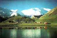
The Pamir is basically composed of Zaalaiysliy range with Lenin
(7134 m) peak, Central part with Communism (7495 m) peak dominating
- the most high point and Revolution (6974 m) peak part, and finally
south-western Pamir with Engels (6510 m) and Marx rock towers grandeur.
 Lenin
(7134 m) peak region Lenin
(7134 m) peak region
Lenin (7134 m) peak - is situated in center of Zaalayskiy range
of
North-Western Pamir within famous Alay valley.
Communism (7495 m) - Korjenevskoy (7105 m) peaks region
Communism (7495 m) and Korjenevskoy (7105 m) peaks are
standing in Central Pamir in front of each other, inviting to make
an ascent by not difficult routs.
Revolution (6974 m) peak region
South-Western Pamir region
South-Western Pamir is situated in the border between Tadzhikistan
and Afghanistan along the ancient Silk road. It presents a large
number of towering rock massifs with more then 1000 meters faces
high difficult for climbing..
|