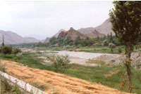
Penjikent (or
Panjikent) is a small town, on the banks of the Zeravshan river,
western Tajikistan.
Many of archaeologists of the world aspire to Panjakent, one
of the centers of ancient civilization, a major sogdian city
was founded in the 5th century.
In the central Zarafshan valley, the town of ancient Panjikent
was the capital of Panch and its rulers. Panjekent was one of
the socio-political, economical and cultural dynamics of the
powerfull and progressive Samanid state. Penjikent is situated
65 km east of Samarqand, in Tajikistan.
What to see
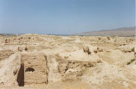
*Ruins of ancient Penjikent , (some 1.5 km from the modern town
of Penjikent) a major Sogdian town arose in the 5th century
A.D.
More about
*History museum in the town.
*Rudaki historical-ethnographic museum in the town.
Getting around
 *Panjikent-Khojand
route is a fantastic scenic route through the high mountains,
climbing in places to over 3500 meters. *Panjikent-Khojand
route is a fantastic scenic route through the high mountains,
climbing in places to over 3500 meters.
*Sarazm, some 20 kilometres from Penjikent, is one of the
most ancient settlements of Central Asia, aged more than 5000
years, dating from the Bronze Age.
*Strange lakes of Muragazor
South of Penjikent lie the Muragazor Lakes, a system of seven
lakes of differing colours that change as the light changes.
* Samarqand (Samarkand) is the major cultural and industrial
center of Tajik people, situated only 65 km west of Penjikent
(now in Uzbekistan). A majestic and beautiful city, Samarkand
is the city of legends .The city is situated in the blossoming
Zerafshan Valley. Samarkand is part of a region that historically
was known as Sogdia, and whose ethnically Iranian (Tajik)
merchants for centuries seem to have played a key role in
the commerce along the Silk Road.
Ancient Panjekent
 Ancient
Panjekent was a small but rich town of the Soghdians, an Iranian
people among the most important peoples of pre-Islamic Central
Asia. The ethnic and territorial name "Soghd/Soghdian"
occurs in historical sources as early as in Iranian Achaemenid
times (6th century B.C.). In their heartland, the Zarafshan
valley, they founded several city-states, as well as colonies
along the ancient Silk Routes from Eastern Europe (Crimea) to
the Chinese border and Mongolia. Ancient
Panjekent was a small but rich town of the Soghdians, an Iranian
people among the most important peoples of pre-Islamic Central
Asia. The ethnic and territorial name "Soghd/Soghdian"
occurs in historical sources as early as in Iranian Achaemenid
times (6th century B.C.). In their heartland, the Zarafshan
valley, they founded several city-states, as well as colonies
along the ancient Silk Routes from Eastern Europe (Crimea) to
the Chinese border and Mongolia.
 The
program starts in Bishkek, situated at the altitude of 720-900
m. The length of cars road is 35 km (the time in the way is
about one hour). On the way from Bishkek to the National nature
Park Ala-Archa tourists will see Kyrghyz villages - Baitik,
Kashka-Suu, visit memorial complex of the leader of Kyrghyz
tribes - Baitik, who united kyrgyz people with Russian within
the 19th century. The park is situated at the altitude of 1880m.
among forest massif of Tien-Shan fir-trees, growing on the slopes
of Ala-archa canyon. Tourists will make a light walk to one
of the canyon - Adigen or Aksai and can watch the change of
the landscapes - from forests to alpine meadows and glaciers.
Lunch. Depart to Bishkek. The
program starts in Bishkek, situated at the altitude of 720-900
m. The length of cars road is 35 km (the time in the way is
about one hour). On the way from Bishkek to the National nature
Park Ala-Archa tourists will see Kyrghyz villages - Baitik,
Kashka-Suu, visit memorial complex of the leader of Kyrghyz
tribes - Baitik, who united kyrgyz people with Russian within
the 19th century. The park is situated at the altitude of 1880m.
among forest massif of Tien-Shan fir-trees, growing on the slopes
of Ala-archa canyon. Tourists will make a light walk to one
of the canyon - Adigen or Aksai and can watch the change of
the landscapes - from forests to alpine meadows and glaciers.
Lunch. Depart to Bishkek.
In the central Zarafshan valley, the town of ancient Panjikent
(Soghdian: Panchekanth) was the capital of Panch and its rulers.
The town probably arose in the 5th century A.D. Its citizens
were well established businessmen and landowners. In A.D. 722,
Arabian forces besieged and took the town. The last ruler Devashtich
fled into the upper Zarafshan regions where he was captured
and sentenced to death shortly after. For some 50 years, ancient
Panjikent stayed a living place under the new rulership, but
towards the end of the 8th century the place was given up and
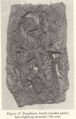
never resettled again. Therefore, quite a lot of urban remains,
architecture and works of art from the last urban phases could
await the spades of the archaeologists. |