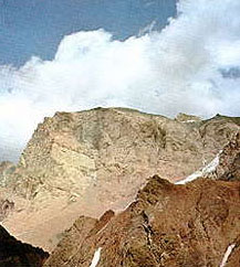
Mt. Zamok, Pamir region |
The Pamirs are the highest upland in the ex-USSR. Roughly rectangular
in shape, they are 280 km long north to south and about 420
km from West to East, totalling 90,000 square kilometres. The
Pamirs are located mainly in Tadzikistan, the northern slopes
of the Trans-Alai stretching to Kyrgyzstan, and its southern
and Eastern outskirts continuing to Afganistan and China.
Its natural borders are the Trans-Alai ridge, with Peak Lenin
(7134 m) and the valleys of the Kyzyl-Su and Surkhob rivers
to the North, the Sarykol ridge to the East, the Pamir and Pyandzh
rivers to the South and again the Pyandzh river and Western
spurs of the Darvaz and Peter the First range to the West.
The Pamirs are divided in two halves by naturally occurring
mountain features. The Eastern Pamirs are a mountainous upland
of Tibetan type, with broad flat high - altitude deserts at
3500 to 4500m. Above these are sloping ridges, such as the Muzcol
ridge, reaching hights of about 6000m. Most of the year they
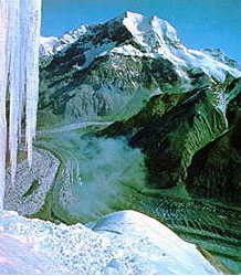
covered with snow and ice. The Western Pamirs are characterised
by deep gorges, rough rivers and high ridges averaging 5000-6000m
and above. Normally they are covered with snow and glaciers.
The Pamir ridges run predominantly West-East and include: the
Trans-Alai ridge with pik Lenin (7134m) as its highest summit,
Peter the First ridge with Pik Moskva (6785m), Darvaz ridge
with Peak Arnavad (6083m), Vanch ridge and Yazgulem ridge with
Pik Revolutsii (6974m).
The snow line rises from 3860m in the west to 5240m in the east.
Nowadays glaciers covers 11% of the Pamir's territory. There
are more than 7000 glaciers here, the main ones being the Fedchenko
glacier (77 km long), Grumm-Grzhimailo (about 37 km), Garmo
(30 km).
The Pamirs are the real
paradise - an "Elysium"
for mountaineers and trekkers. |
The north-western Pamirs is the district preferred by climbers
because it contains three of the four seventhousanders of
ex-USSR, 110 of the 135 sixthousenders, endless summits over
5000m and lots of unclimbed routes. There are over 600 classified
routes here, mainly of mixed character, from grades 2 to 6.
In the 1970s the first International Mountaineering Camp was
established at Achik-Tash on the Northern side of Peak Lenin.
Further camps were opened on Fortambek glacier for tackling
Peak Kommunizma and on the Moskvina glacier for Peak Evgenii
Korzhenevskoy.
The optimal period for climbing in this region is July-August.
Russian climbers did the winter ascent, usually in February,
since the mid-1970s.
|